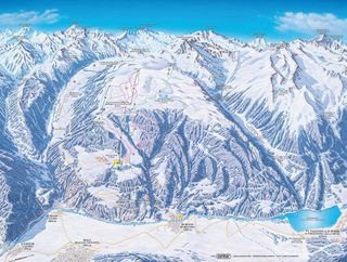
| Highest point: | 2,520 m |
| Lowest point: | 1,750 m |
| Altitude ski resort: | 921 m |
| Lifts in total: | 4 |
| Gondola lift: | 0 |
| Chair lifts: | 2 |
| Tow lifts: | 2 |
| Pistes in total: | 10 km |
|
Pistes:
|
4 km |
|
Pistes:
|
5 km |
|
Pistes:
|
1 km |
| Ski routes: | 4 km |
Ski vacations Sluderno – sunny centre point in the Vinschgau!
Sluderno
In the Upper Venosta Valley (German: "Vinschgau"), between Matschertal and the Ötztal Alps, the muncipality Sluderno (German: "Schluderns") is located on an altitude of 921 m. The sunny resort shows its rich history as a traditional mountain village with its coloured house facades and the gothic Katharin's church. The cultural Region of Venosta is characterised by a far-reaching cultural history and much historic evidence, and the Vinschgau Museum in Sluderno conveys South Tyrolean customs in permanent and circulating exhibitions. The resort's landmark, the impressive castle dating back to the 13th century, Castel Coira, sits enthroned above the village. You can see the Ortler from afar and the snowy alpine pastures invite you to take walks, tobogganing, or skiing.Sluderno is not only a close-to-nature resort in between soft mountain slopes, its geographic location is also especially favourable when wanting to explore several ski regions. Private bus companies offer transfers to various ski areas in the surroundings. Here you can choose between two extensive ski tours where everyone will find their preferred skiing paradise.
Ortles Region
Amidst the national park of Stilfserjoch, framed by 14 peaks, each above an altitude of 3,000, lies the Ortler region. Its named after the 3,905 m high, most well-known glacier in the eastern Alps. The grandiose landscape surrounding the Ortler captivates both visitors of winter and summer. Around the Ortler, you can experience pure skiing fun from November - May, including the impressive panoramic view of the Ortler, Cevedale, and the Königsspitze.Travel Sluderno
- By train: Malles Venosta (approx. 5 km), Marling (approx. 50 km)
- By plane: Innsbruck (approx. 145 km)


